Flying in Wellington requires a bit of local knowledge
Rochelle Fleming, instructor and forecaster joined us on Wednesday night to share some of her knowledge of weather and flying out of Wellington.
Rochelle is moving to Taranaki with her family, after being involved with the Club for about 15 years. We wish you all the best Rochelle!
Rochelle is moving to Taranaki with her family, after being involved with the Club for about 15 years. We wish you all the best Rochelle!
Outsmarting the weather
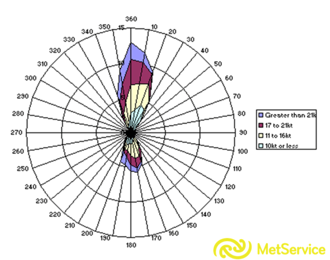
Wind is usually the thing that stops us flying, because of the acceleration of air through Cook Strait. Due to the orientation of Cook Strait, the wind can only really blow either northerly or southerly at Wellington Airport, as shown below.
Although the wind usually blows parallel to the isobars (if you stand with your back to the wind, the low pressure is on your…?), due to the surrounding terrain, the wind will often blow across the isobars through Cook Strait. The wind will ALWAYS blow from high to low pressure – like water running down hill.
How close the isobars are indicates the strength of the wind.
How close the isobars are indicates the strength of the wind.
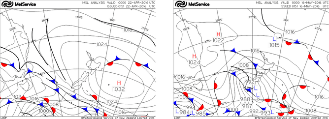
On the left, the wind was 15kt, while on the right it was 25G40kt. If the isobars have a N/NE tilt (as they slightly do in the analysis on the left), it won't be as windy (for the same gradient) as if the direction is NNW to W. This is because when the air hits the Tararua Range, it prefers to run along them, rather than go over. This is similar to what happens with the Southern Alps. The accelerated air then squirts through Cook Strait and due to the venturi effect is accelerated further.
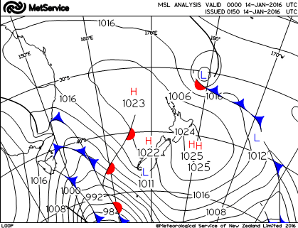
This is an example of the "usual" situation in summer (above). We often see a ridge lying north of Cook Strait, resulting in northerlies in Wellington. Due to strong heating over inland Marlborough, a heat low develops and the pressure gradient is enhanced. On the day shown above, the northerly had increased to 18G28kt by late afternoon, and this is fairly typical. For this reason, you should try and make a booking first thing in the morning in spring and summer, even if it doesn't look like it will be that windy. Also, if you see in the forecast 15kt, or 20kt, you should suspect that it will in reality be gusty.

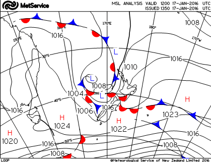
This example (above) is a classic one of a front approaching and the northerly gusting 50kt at NZWN.
"Round the corner southerly"
The "best" way for NZWN to get very low stratus or fog (sea fog) is in the situation where there's a northeast flow over the North Island and moisture is advected from the tropics. In this situation, Cook Strait will be a southerly (lower pressure to the north), so the warm, moist air gets dragged in over cold seas. The sea will cool the lowest layer of the atmosphere, moisture will condense and stratus or fog will form. This then gets advected into Wellington Airport. In these situations, fog can persist even if the wind is very strong, all it is doing is bringing in more moisture. Fog/stratus can come in any time of day, although in summer the heat from the runway may burn the fog off. In this case, you may see a fog bank sitting over the southern end of the runway. As soon as it cools down, the fog will roll completely in. The critical thing to determine whether the fog or stratus will come in is the direction of the 2000ft (Mt Kaukau) wind. If it is south of 130°T the fog/stratus will come in. If it is north of that, it won't.
Here's what the METARs looked like in the above situation:
10am 34008KT 9999 NCD 22/15 (2000ft wind 36010KT)
11am 16010KT 4200 HZ BKN001 16/14 (2000ft wind 01010KT)
200ft for most of the day (2000ft wind less than 10kt)
2000ft wind turned southerly late afternoon
6pm 19014KT 1400 DZ BR VV002 16/15 (2000ft wind 17018KT)
FOG overnight
2am 19007KT 9999 NCD 16/15 (2000ft wind 12010KT)
Notice how the fog cleared at 2am, when the 2000ft wind turned more easterly.
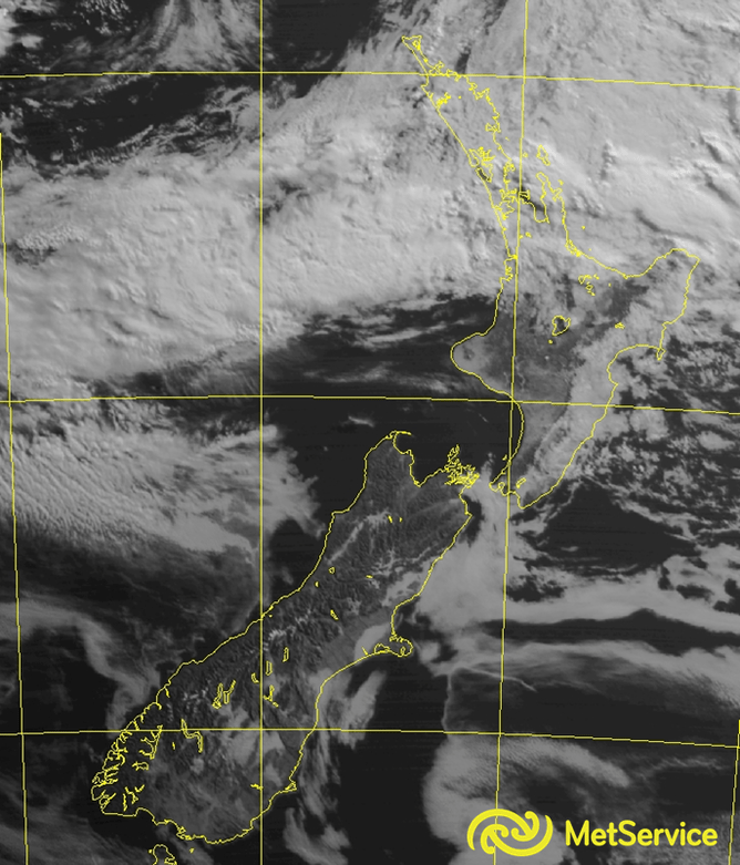
Here's an example of sea fog in visible satellite imagery (not from the same situation as the isobaric analysis). Remember, visible imagery shows where the cloud is, but doesn't tell us the base. It's only available during the day (why?).
Fog and low cloud in these situations can last for several days - it will only clear if the wind direction changes (which may only be temporary, the threat will persist) OR there's a change of airmass.
Fog and low cloud in these situations can last for several days - it will only clear if the wind direction changes (which may only be temporary, the threat will persist) OR there's a change of airmass.
Other hints about southerlies
If there's a southerly change forecast, check the observation at Kaikoura. The "standard" time it takes to get to Wellington from Kaikoura is 3 hours (6 hours from Christchurch). Be careful though, they can travel faster (or much slower). Kaikoura will also give you a hint about how strong it might be when it comes through Wellington (again, depending on wind direction and other factors, it could be significantly stronger (or weaker) through Wellington).
If you're expecting low cloud in Wellington and it's a southerly (not the round the corner situation), you can get a clue about how low the cloud might be by checking what the base at Kaikoura is. Beware though that the ceilometer is 200ft AGL at Kaikoura.
If you're expecting low cloud in Wellington and it's a southerly (not the round the corner situation), you can get a clue about how low the cloud might be by checking what the base at Kaikoura is. Beware though that the ceilometer is 200ft AGL at Kaikoura.
Blocking
There are a number of different blocking set-ups, but the easiest way to think of it is if there's a low lying north of a strong high. The upper level westerly flow splits and weather systems over NZ's latitudes can't make much progress eastwards.

These situations can result in settled weather, so are generally more predictable. The uncertainty arises around the breakdown of the block, as models usual struggle with the timing. In these situations you can be reasonably confident of the forecast, up until the point when the block starts to breakdown.
Best weather in Wellington
- Dying southerly
- NE flow (if it's NE enough that low cloud isn't a problem)
- Critical SW flow (if it's not too strong)
- Look for the ridge axis right over Cook Straight, or to the south
Resources
www.metservice.com
Usually the model data will be either from the UK or the European model, which is most commonly used by the forecast room. There is also local model data available, which has better representation of NZ's terrain, but there are other limitations. Forecasts prepared by humans may incorporate elements of many different models, so what you see in raw model data won't always match written forecasts.
Lots of resources on here. Model data comes from the USA, and is the same as what most other websites use that make model data available (its free). Data goes out to 10 days. NZ forecasters usually favour the UK model, or sometimes the European model.
http://www.ecmwf.int/
This is the European model. Basic isobaric progs are freely available, but the interface isn't that nice.
Usually the model data will be either from the UK or the European model, which is most commonly used by the forecast room. There is also local model data available, which has better representation of NZ's terrain, but there are other limitations. Forecasts prepared by humans may incorporate elements of many different models, so what you see in raw model data won't always match written forecasts.
- Startwith "Marine" – coastal (COOK) and then recreational (Wellington). The marine forecaster is focusing almostsolely on wind, so this should be the best wind forecast. There is also anextended outlook. If you see 30kt in theCOOK coastal, then you can expect 30kt as the 2000ft wind and gusts of 30kt atWellington Airport.
- Use the "Rural" tab – Wellington. The public forecasters spend most of theirtime on these forecasts. Don't worry toomuch about graphs and numbers (unless that's your thing), because these arepurely model driven and shouldn't be used too literally. Days 1-6 have human input, after that it'sjust model data. You can use it, butwith caution. The confidence you canhave in a long range forecast varies depending on the situation. For example, in a springtime westerlysituation you can look out to 10 days and see it's a disturbed westerly flow,but you wouldn't put money on the timing of fronts coming through.
Lots of resources on here. Model data comes from the USA, and is the same as what most other websites use that make model data available (its free). Data goes out to 10 days. NZ forecasters usually favour the UK model, or sometimes the European model.
http://www.ecmwf.int/
This is the European model. Basic isobaric progs are freely available, but the interface isn't that nice.